The battle occurring in the southern Philippine city of Marawi between supporters of Islamic State and the Philippine’s government, has raised many fears. The militaries of Indonesia, Malaysia and Philippines have launched coordinated maritime patrols in order to face potential threats such as piracy, kidnapping, terrorism and other crimes in regional waters.
Mandatory Transit Corridors in SE Asia
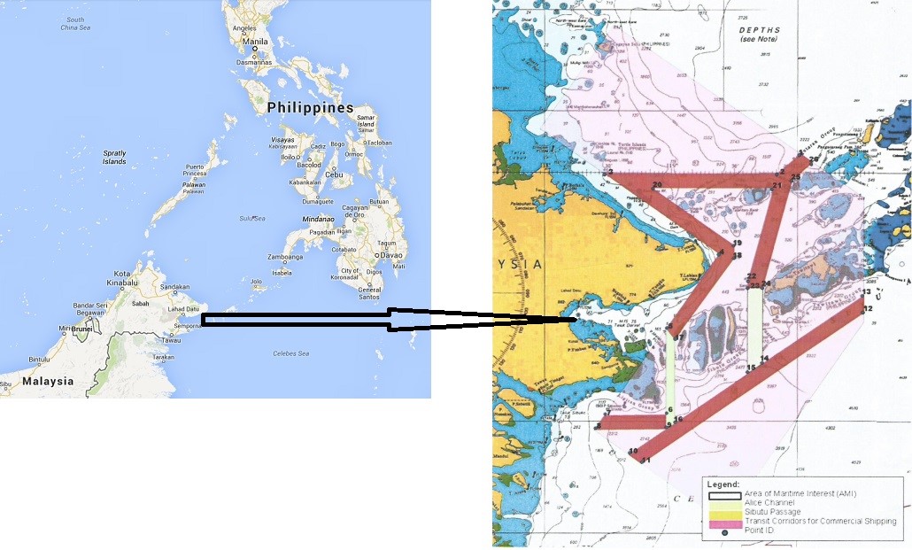
Following those measures and in order to enhance maritime security the Marine Department of Malaysia, Sabah Region requires, all vessels which sailing through the designated maritime areas of common concern (see exact coordinates and map in Annex A), to pass through designated maritime corridors/transit lanes with specific coordinates as shown below:
| POINT ID | LATITUDE | LONGITUDE |
| (1) | 06 09 15.8 N | 119 59 46.0 E |
| (2) | 05 59 36.0 N | 119 48 59.0 E |
| (3) | 05 59 36.0 N | 118 27 08.3 E |
| (4) | 05 21 00.0 N | 119 21 30.0 E |
| (5) | 04 44 59.0 N | 118 56 30.0 E |
| (6) | 04 03 30.0 N | 118 56 30.0 E |
| (7) | 03 56 30.0 N | 118 56 30.0 E |
| (8) | 03 59 14.0 N | 119 00 30.0 E |
| (9) | 04 39 43.0 N | 119 00 30.0 E |
| (10) | 04 03 00.0 N | 118 27 21.5 E |
| (11) | 03 56 00.0 N | 118 22 30.0 E |
| (12) | 03 44 12.5 N | 118 38 46.8 E |
| (13) | 03 39 48.6 N | 118 44 51.1 E |
| (14) | 04 52 45.7 N | 120 30 00.0 E |
| (15) | 05 01 16.7 N | 120 30 00.0 E |
| (16) | 04 28 08.0 N | 119 42 00.0 E |
| (17) | 04 23 16.0 N | 119 35 00.0 E |
| (18) | 05 04 35.0 N | 119 35 02.0 E |
| (19) | 05 04 35.0 N | 119 42 00.0 E |
| (20) | 05 19 00.0 N | 119 28 37.0 E |
| (21) | 05 25 04.0 N | 119 28 37.0 E |
| (22) | 05 52 36.0 N | 118 49 51.9 E |
| (23) | 05 52 36.0 N | 119 47 06.0 E |
| (24) | 05 07 45.0 N | 119 35 02.0 E |
| (25) | 05 56 30.0 N | 119 56 00.0 E |
| (26) | 06 05 08.0 N | 120 05 38.5 E |
Reporting requirements
All vessels are required to provide a report to National Coast Watch Center (NCWC), LMS Bongao, MCC Philippines, CGAC, NOC, MCC Malaysia and MMC Indonesia at least 24 hours before arrival at the designated maritime areas of common concern, describing the ship’s routing information.
| AGENCY | EMAIL ADDRESS/CONTACT |
| National Coast Watch Center (NCWC) | [email protected] +63 (2) 2413104 |
| Naval Operation Center (NOC), Philippine Navy | [email protected] [email protected] +63 (917) 8512708 +63 (2) 5244981 |
| Coast Guard Action Center (CGAC), Philippine Coast Guard | [email protected] +63 (917) 7243682 +63 (2) 5273877 |
| Naval Forces Western Mindanao Operation Center | [email protected] [email protected] +63 (917) 6860681 |
| Maritime Research Information Center (MRIC) | [email protected] +63 (917) 7085248 +63 (2) 8431833 |
| Maritime Command Center (MCC), Tawau Malaysia | [email protected] +6089 775600 +6089 779777 +6089 982623 (5.00pm – 8.00am) |
| Eastern Sabah Security Command (ESSCOM) Malaysia | [email protected] +6089 863181 |
| Marine Department Malaysia, Sabah Region | [email protected] +6088 401111 |
| Maritime Command Center (MCC), Tarakan Indonesia | [email protected] [email protected] +625513806288 +625513806289 |
Upon entering the designated maritime areas of common concern a reporting procedure via radio with the monitoring station should be rendered. Then all vessels are required to pass through the designated transit corridors launched by Sabah Region.
Other Security Corridors
Further to the required security corridors issued by the Marine Department of Malaysia, the Philippine Department of Transportation has also launched a recommended transit corridor to prevent acts of piracy and armed robbery (Circular 2017-15).
Also, new limits regarding the High Risk Area (HRA) in Somalia have already been set (Circular 2015-12) and they should be taken into serious account.
Actions required
Ship managers and operators should:
- Provide every vessel with an effective Ship Security Plan.
- Follow the required transit corridors in SE Asia.
- Follow the recommended maritime security transit corridors whether available.
- Follow best practices (as required in BMP-4) and consider the use of embarked armed security.
- Have their crews adequately trained and familiarized with any protective measures onboard.
Annex A
The coordinates of designated areas of common concern are listed below:
| POINT | LATITUDE | LONGITUDE |
| A | 07 11 00 N | 118 32 00 E |
| B | 05 48 00 N | 120 30 00 E |
| C | 04 48 00 N | 120 30 00 E |
| D | 03 11 33 N | 119 23 52 E |
| E | 03 56 00 N | 118 22 30 E |
| F | 05 21 00 N | 119 21 30 E |
| G | 06 21 00 N | 117 57 00 E |
The maritime security transit corridors in SE Asia are given in the next map:
You may find further information at SAFETY4SEA
See also our related product

