Recent attacks against merchant shipping by pirates and armed robbers in Philippines, Western Indian Ocean and Red Sea Regions have highlighted the risks associated with transiting these waters. As a result, new security transit corridors have been developed in the aforementioned areas.
Moro Gulf & Basilan Strait
The Philippine Department of Transportation in order to address the increasing threats to shipping in the areas of Moro Gulf and Basilan Strait provides a Recommended Transit Corridor (RTC) to prevent or suppress acts of piracy and armed robbery transiting said maritime areas.
All vessels transiting Moro Gulf and Basilan Strait, except government vessels utilized for maritime law enforcement, should follow this RTC. The RTC is not a traffic separation scheme. The reason behind the RTC is to provide PCG and other law enforcement units’ awareness over the operating environment in and around areas of Moro Gulf and Basilan Strait by designating transit areas where vessels can be easily monitored and law enforcement units are deployed nearby.
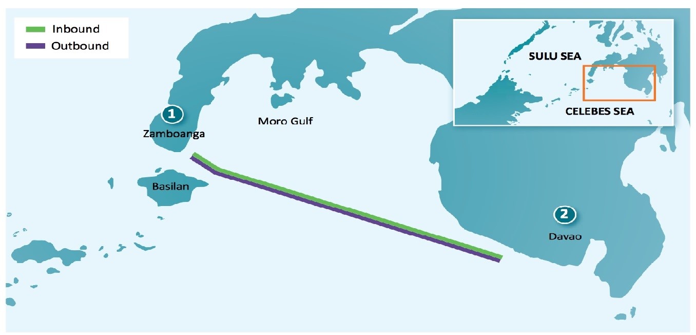
The RTC shall be reflected on the NAMRIA Chart 4511 and Chart 4708. The corridor includes an inbound and an outbound transit lane that will be 1 nm wide and will be separated by a 0.50 nm buffer zone.
The geographical position regarding the two lanes is:
INBOUND TRANSIT LANE
| Point (A) | Lat 6o 51’ 2.00”N | Long 122o 12’ 54.51” E |
| Point (B) | Lat 6o 42’ 5.93”N | Long 122o 23’ 54.15” E |
| Point (C) | Lat 5o 54’ 46.76”N | Long 124o 29’ 42.18” E |
| Point (D) | Lat 5o 54’ 2.54”N | Long 124o 29’ 19.18” E |
| Point (E) | Lat 6o 41’ 15.56”N | Long 122o 23’ 34.72” E |
| Point (F) | Lat 6o 50’ 32.79”N | Long 122o 12’ 10.27” E |
OUTBOUND TRANSIT LANE
| Point (G) | Lat 6o 50’ 17.18”N | Long 122o 11’ 44.76” E |
| Point (H) | Lat 6o 40’ 42.56”N | Long 122o 23’ 31.19” E |
| Point (I) | Lat 5o 53’ 39.11”N | Long 124o 29’ 6.46” E |
| Point (J) | Lat 5o 52’ 58.10”N | Long 124o 28’ 42.20” E |
| Point (K) | Lat 6o 39’ 54.05”N | Long 122o 23’ 15.07” E |
| Point (L) | Lat 6o 49’ 44.95”N | Long 122o 10’ 56.47” E |
In the below map the two (2) transit lanes are clearly depicted within the Moro Gulf:
Gulf of Aden & Bab Al Mandep
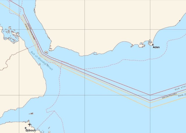
The Combined Maritime Forces (CMF) are establishing a Maritime Security Transit Corridor (MSTC) to address the multiple types of risks dealing with transits through the Gulf of Aden, Bab Al Mandep, and associated waters.
The purpose of this corridor is to provide a recommended merchant traffic route around which Naval Forces can focus their presence and surveillance efforts. The formation of the MSTC has no effect on the use or timings of Group Sails or escorted transits of the IRTC. These will continue to be scheduled and executed as previous and IRTC points will remain existent.
The MSTC will consist of:
- The Internationally Recommended Transit Corridor (IRTC)
- The BAM TSS and the Traffic Separation Scheme (TSS) West of the Hanish Islands
- A two-way route directly connecting the IRTC and the BAM TSS
Two-way route directly connecting the IRTC and the BAM TSS:
Actions required
Ship managers and operators should:
- Provide every vessel with an effective Ship Security Plan
- Follow the recommended MSTC regarding the high risk areas.
- Follow best practices (as required in BMP-4) and consider the use of embarked armed security
- Have their crews adequately trained and familiarized with any protective measures on board
You may also find further information at SAFETY4SEA
See also our related product

