Overview
The High Risk Area (HRA) is an area within the UKMTO designated Voluntary Reporting Area (VRA) that is considered to be of high risk for piracy activities and as such, within this area, self-protective measures are most likely to be required.
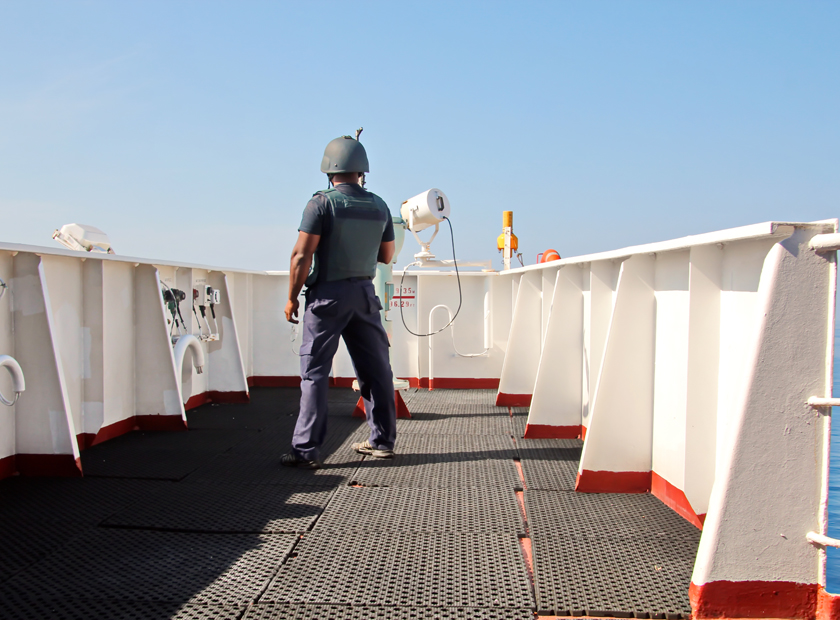
When planning routes through the High Risk Area, it is important to consider the latest information regarding the location of where pirates are operating. It is also important vessels to be prepared to alter course at short notice to avoid pirate activity when information is provided by NAV WARNINGS and/or Naval/ Military forces. Weather can also constitute an obstacle to pirates and can be considered as an additional factor when planning a route through the High Risk Area.
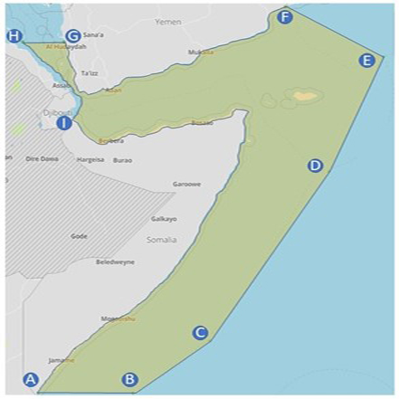
New Borders for High-Risk Area – Indian Ocean
Major shipping groups, including BIMCO, ICS, INTERCARGO, INTERTANKO, and OCIMF, announced a reduction of geographic boundaries of the ‘High Risk Area’ for piracy in the Indian Ocean, effective from 1 September 2021.
The HRA was created at the height of the Somali piracy threat in 2010 to show shipowners, operators, and seafarers where pirates operated and where extra vigilance was required to avoid attacks. Nowadays, Somali piracy has been suppressed while West Africa’s Gulf of Guinea is considered as world’s most dangerous waters. The HRA was last amended in May 2019, and the industry groups, after consulting with companies and militaries, began a further review of the extent of the area in February 2021. Due to a continued downward trend in Somali piracy, the changes, agreed in August 2021, reduce the HRA boundaries to the Yemeni and Somali Territorial Seas and Exclusive Economic Zones in its eastern and southern reaches.
Source: ICS
Coordinates:
- Position B (01° 30’ S – 046° 00’ E), a line to
- Position C (01° 00’ N – 049° 30’ E), a line to
- Position D (09° 00’ N – 055° 00’ E), a line to
- Position E (14° 20’ N – 057° 30’ E), a line to
- Position F (the Yemen coast at longitude 053° 00’ E), then
- Follow the Yemeni coast westwards and northwards, to
- Position G (the Yemeni Red Sea coast at latitude 15° 00’ N), then a line to
- Position H (the Eritrea territorial sea border at latitude 15° 00’ N), then
- Follow southwards first Eritrea’s and then Djibouti’s territorial sea borders, to
- Position I (the coastal border point between Djibouti and Somalia), then
- Follow the Somali coast eastwards and then southwards, to Position A
The organizations, in consultation with international partners, will also take a comprehensive new approach to assessing international maritime security threats to allow shipowners and operators to fully gauge the risk of voyages worldwide. This second step is expected to be completed by 31 December.
Piracy globally at lowest level in 27 years
Apart from Somalia, an overall decline has been noticed in reported incidents. Specifically, in first half of 2021, IMB received reports of 68 incidents of piracy and armed robbery against ships globally, down from 98 incidents during the same period last year and the lowest number for first half of any year since 1994. However, violence against crews has continued with 50 crew kidnapped, three each threatened and taken hostage, two assaulted, one injured and one killed. 32% of all reported incidents took place in Gulf of Guinea, with the region also accounting for all 50 kidnapped crew and the single crew fatality recorded in this period.
Actions required
Ship managers and operators should be aware of the limitations and precautions within High Risk Area in Horn of Africa-Indian Ocean, West Africa and Gulf of Guinea and in Malacca straight and SE Asia. Industry feedback and best practices (as required in BMP-5) to be followed and an effective Ship Security Plan to be also in place in order to avoid detection and attacks by pirates.
How we may help
SQEMARINE can provide guidance on revision or development of an effective Ship Security Plan.